
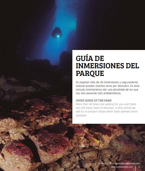
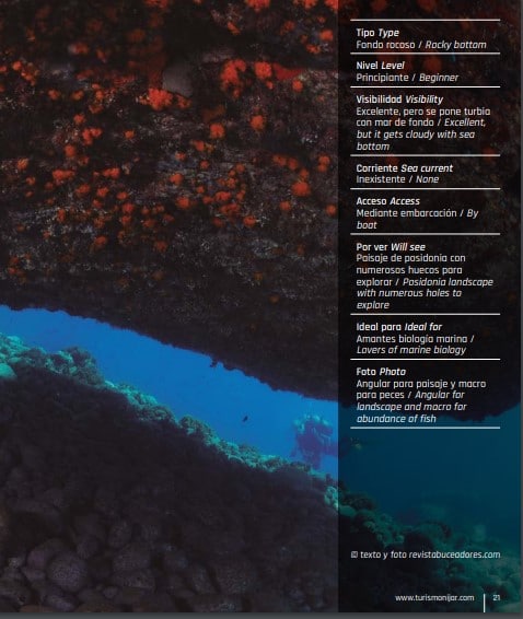
Guia de Inmersiones en Cabo de Gata
TIERRA DE VOLCANES Y OASIS DE MAR
La costa de Níjar es de naturaleza volcánica, árida y desprovista de vegetación. La erosión la ha esculpido con atractivas y caprichosas formas y colores. Paredes de acantilados “interrumpidas” por enormes playas o pequeñas calas de gran
belleza y, algunas, prácticamente solitarias. Sorprende que estas altas paredes no continúen su estructura bajo el agua, cayendo a enormes profundidades.
Ya en el agua, no suelen sobrepasarse los 4/5 m de profundidad, debiendo alejarnos a cierta distancia para llegar a los -14/15 m.
Prácticamente todos los fondos están colonizados por Posidonia.
Gracias a ella y a los fondos de arena, estas aguas lucen ese bello color turquesa “tipo Caribe”, tan espectacular. La abundancia de posidonia proporciona cobijo y alimento a multitud de especies, motivo quizás de la gran densidad y diversidad de peces e invertebrados presente en el Parque.
LAND OF VOLCANOES AND SEA OASES
The coast of Níjar is of volcanic, arid and devoid of vegetation nature. Erosion has carved it with attractive and unusual shapes and colours.
Cliffs’ faces are “broken” by long beaches or small secluded coves of great beauty.
It is surprising that these high walls do not continue their structure under water, falling to huge depths.
Already in the water, they do not usually surpass the 4/5 m of depth, having to move away to some distance to reach the -14/15 metres. Nearly all seabeds are colonised by posidonia. Thanks to it and the sandy bottoms, these waters have a beautiful shade of turquoise colour as impressive as the Caribbean Sea. The abundance
of posidonia provides shelter and food for a great number of species, perhaps because of the great density and diversity of fish and invertebrates present in the Park.
El Vapor
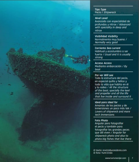
EL VAPOR
Se le conoce por El Vapor cuando en realidad su verdadero nombre es Arna. Se hundió en 1928 al golpear contra La Laja, una cresta de
montaña que está cercana a la superficie cerca del Cabo de Gata.
Tiene prácticamente 100 m de eslora por 15 m de manga, la parte menos profunda de la cubierta está situada a 26 m alcanzando los 42 m en la arena.
Debido a su envergadura, necesitaremos más de un buceo para familiarizarnos con él. Aunque tiene varias redes enganchadas en su estructura, no representan ningún peligro de enganche ya
que las aguas suelen estar claras. Es un pecio antiguo y está algo deteriorado por el paso de los años, pero la vida se refugia en su inmensa estructura. Emblema de la zona, bucear en él es un auténtico espectáculo, allí donde todos quieren ir.
Si es posible, aconsejamos utilizar aire enriquecido. Si el mar no está en perfectas condiciones es una inmersión para buceadores avanzados y tek, ya que la corriente suele ser fuerte o muy fuerte, debido a que está en la punta más expuesta de la península. Es
conveniente llevar linterna o foco.
He is known as El Vapor but his real name is Arna. It sunk in 1928 when it had a collision with La Laja, a mountain ridge that is close to the surface near Cabo de Gata.
It has practically 100 m of length by 15 m of beam. The shallower part of the deck is located to -26 m reaching the -42 m in the sand.
Because of its size, we will need more than one dive to familiarize ourselves with it. Although it has several nets hooked in its structure, they do not represent any danger of hooking since the waters are
usually clear. It is an old shipwreck and it is somewhat deteriorated by the passaging of the years, but life takes refuge in its immense structure. It is an emblem in the area, diving here is a real show; this is the place where everyone wants to go.
If possible, we recommend using enriched air. If the sea is not in perfect condition it is a dive for advanced divers and tech, since the current is usually strong or very strong, because it is at the most exposed tip of the peninsula. It is advisable to carry a torch or
flashlight.
LOS AMARILLOS O LOS BURROS
Amarillos por el color de la pared de un acantilado cercano, aunque también se la conoce por Los Burros, por la gran cantidad de peces ballesta que vivían en estas rocas.
La inmersión se desarrolla sobre dos formaciones rocosas separadas por un canal de arena y totalmente visibles entre ellas. Esta inmersión
carece de boya de fondeo y se acostumbra a echar el ancla en el pasadizo arenoso para facilitar su encuentro en el ascenso.
El fondo no tiene ningún interés especial en cuanto a belleza se refiere, pero al estar en un fondo arenoso relativamente lejano a la costa, la vida busca protección en él resultando muy abundantes los meros, falsos abadejos, corvas y serviolas y, si prestamos atención al azul, no es raro ver peces luna.
La profundidad oscila entre 18 m y 21 m. Al estar este punto de buceo un poco alejado de la costa, puede haber algo de
corriente. Ideal utilizar nitrox.
It is called yellow by the colour of the wall of a nearby cliff, although it is also known as The Burros, because of the great amount of triggerfish that lived in these rocks. The dive takes place on two rock
formations separated by a channel of sand and totally visible between them.
This dive does not have a mooring buoy and normally the anchor is casted in the sandy passage to locate it in the ascent. The seabed is not very interesting as far as beauty is concerned, but since
it is in a sandy bottom quite far from the coast, life seeks protection in it. As a result there are many groupers, gold-blotch grouper, sea bass and amberjacks, and if we pay attention to the blue, it is not
uncommon to see sunfish.
The depth varies between 18 m and 21 m.
As this dive point is away from the coast, there may be some current.
It is ideal to use nitrox.
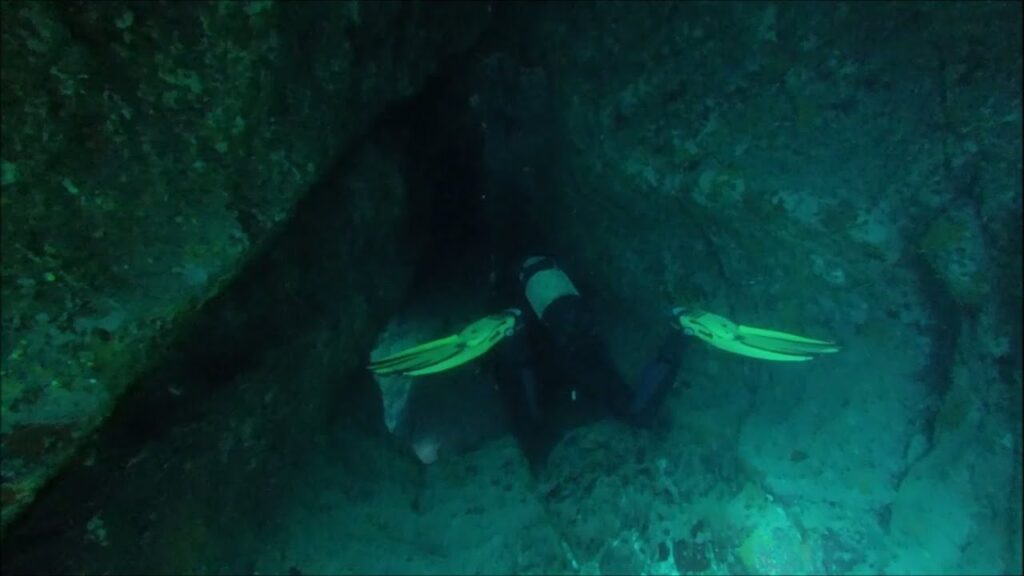
EL TÚNEL NARANJA
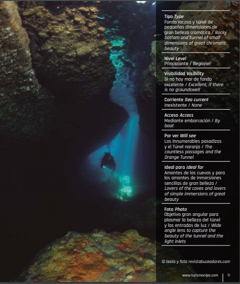
Por caprichos de la geología, se ha formado un túnel submarino de unos 50 m de longitud en las paredes de un acantilado volcánico.
La entrada se ve desde superficie, pero además del propio túnel, enormes bloques de roca forman innumerables pasadizos, tapizados de Posidonia que aumentan todavía más su belleza.
Es un buceo muy poco profundo La profundidad máxima que podemos alcanzar es de unos 12 m y la mínima es la superficie, pues en el interior del túnel se abren varias bóvedas de pequeñas dimensiones que permiten salir a respirar.
Aparte de los diferentes tipos de peces que podemos encontrar, el mayor encanto de este buceo radica en el colorido del túnel: la gran cantidad de esponjas y corales de color naranja de sus paredes le confieren una belleza especial, acrecentada
según la hora del día por bellos contraluces.
Inmersión para todos los niveles de buceo.
Es conveniente ir provistos de linterna o foco.
By whims of geology, an underwater tunnel of about 50 m in length has been formed on the walls of a volcanic cliff. The entrance can be seen from the surface, but in addition to the tunnel itself, huge rock
blocks forming countless passages and Posidonia meadows increase its beauty even more.
It is a very shallow dive. The maximum depth we can reach is about 12 m and the minimum is the surface, because inside the tunnel there are several domes of small dimensions that allow breathing out.
Apart from the different types of fish that we can find, the greatest charm of this dive lies in the colour of the tunnel: the large amount of orange sponges and corals on its walls gives it a special beauty, increased by wonderful backlighting according to the time of day. This immersion is for all levels of diving.
It is convenient to have flashlight or torch.
EL CHALET DEL FRANCÉS
También conocida como La Cueva del Francés. Está situada a unos 16 m de profundidad, un poco alejada de la pared del acantilado, siendo un poco difícil de encontrar si no utilizas los servicios de un guía de buceo.
Es una pequeña cueva sobre un fondo de arena, repleta de pequeños
“reyezuelos”, en la que el dueño y señor es un mero de gran tamaño, confiado a distancia pero que huye hacia el interior cuando nos acercamos. Aparte del mero, la belleza paisajística radica en varios pasillos de lava colonizados por la ya mencionada Posidonia y también por varias cuevas/cavernas que penetran en la pared del acantilado.
La fauna, la típica del parque, pero más abundante en cuanto a meros se refiere.
También se suelen ver cigarras. Es conveniente ir provistos de linterna o focos
It is also known as La Cueva del Francés. It is located about 16 m deep, is a little far away from the cliff, and is a little difficult to find if you do not use the services of a dive guide.
It is a small cave on a sandy bottom, full of small cardinalfish, in which the owner and lord is a large grouper, it is confined at a
distance but it flees to the interior when we approach. Apart from the grouper, the scenic beauty lies in several lava halls colonized by the
aforementioned Posidonia and also by several caves / caverns that
penetrate the cliff face. The fauna is the typical of the park, but more abundant as far as groupers is concerned.
Slipper lobsters are also commonly seen. It is advisable to have flashlight or torch
LA RESTINGA DE LAS ANCLAS
El punto de buceo está situado a media milla de la batería de San Felipe. Antiguamente en esta inmersión había varias anclas, en la actualidad solamente queda una. Es un ancla de gran tamaño del siglo XVIII, que debemos visitar. Pero la parte más interesante del buceo es una barra rocosa que se eleva unos 2 m sobre el fondo y tiene unos 400 m de longitud. La parte alta de esta barra está colonizada por Posidonia hasta donde empieza la caída rocosa y se
forman multitud de huecos. Allí es donde encontramos los meros, abadejos, morenas, corvas y, si estamos alertas, seguro que vemos serviolas y algún pez luna.
El punto más profundo alcanza los 14 m, pero la profundidad media no sobrepasa los 12 m.
Recomendable linterna para mirar en el interior de los agujeros.
The diving point is located half a mile from the San Felipe battery.
Formerly in this dive there were several anchors, at present only one remains. It is an anchor of great size of century XVIII, which we must
visit. But the most interesting part of the dive is a rocky barrier that rises about 2 m above the bottom and is about 400 m long. The upper part of this barrier is colonized by
Posidonia up to where the rocky fall starts and a lot of holes are formed. That’s where we find grouper, goldblotch grouper, moray eels,
and, if you are aware, we are sure you will see amberjack and some sunfish. The deepest point reaches the 14 m, but the average depth does not exceed 12 m.
It is recommended to have flashlight to look inside the holes.
LA PIEDRA DE LOS MEROS
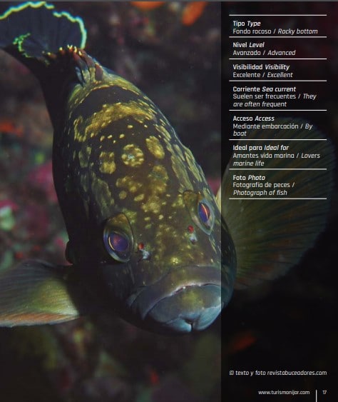
Es uno de los puntos de buceo más alejados de la costa. Un
conjunto de rocas que emergen de 32 m a 26 m. Carece de belleza paisajística, pero la vida bulle en todo el buceo, aunque se mantiene a
relativa distancia del buceador.
No existe boya de fondeo y se tira el ancla. Es conveniente descender por el cabo, pues suelen ser frecuentes las corrientes. Desde la superficie se suele ver el fondo y, conforme vamos descendiendo, empezamos a ver las siluetas de los bancos de barracudas. Cuando tocamos fondo, grandes meros, abadejos, corvas y enormes bancos de
dentones cazando, ¡todo un espectáculo! También una enorme ancla reposa sobre las rocas.
Es un fondo bastante plano y hay que estar pendientes del ordenador si no queremos entrar en deco, embelesados por la cantidad de vida de nuestro alrededor. Según nos indicaron, es frecuente el avistamiento de peces luna y águilas de mar. Ideal utilizar nitrox para incrementar tiempo en el fondo.
It is one of the dive points farthest from the coast. It is a set of rocks that emerge from -32 m to -26 m. It lacks picturesque beauty, but there is a great amount of life throughout the dive, although it remains at a relative distance from the diver.
There is no mooring buoy and the anchor is thrown. It is convenient to descend by the cape, since currents are frequent. From the surface
you can see the background and, as we descend, we begin to see the shapes of the shoal of barracudas. When we hit the bottom, we can see big groupers, haddocks, sea bass, and huge shoals of common
dentex, a real show! Also a huge anchor rests on the rocks.
It is a quite flat bottom and you have to be aware of the computer if you do not want to go into decompression, fascinated by the quantity
of life around us. As we were told, there is frequent sighting of sunfish and eagle rays. It is Ideal to use nitrox to increase time in the background
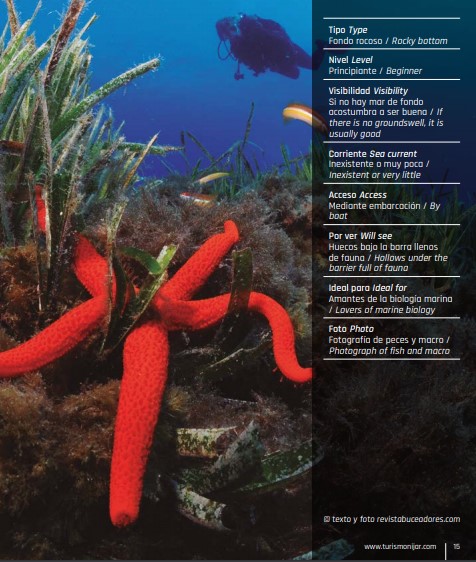
LA AMATISTA
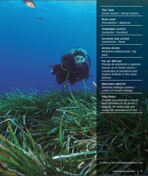
Este punto de buceo está situado bajo un mirador en la carretera que lleva su mismo nombre. El fondeo se realiza en una boya del Parque. Es una inmersión de gran belleza paisajística. Se recorren una
serie de pasadizos, como si de dedos de la mano se tratara, que van desde los -5 m en la parte menos profunda a los -14 m en la situada a mayor profundidad. Todo el fondo está cubierto de Posidonia, quedando solamente al descubierto los canales de arena. Es muy fácil orientarse, pues bastará seguir el contorno de estos canales, que forman diversas grietas y oquedades que sirven de hábitat a meros, corvas, morenas y algún despistado pulpo.
Es apta para todos los niveles de buceo.
This diving point is located under a viewpoint on the road that bears the same name. The mooring is done in a buoy of the Park. It is an immersion of gorgeous beauty. There are a series of passages, as if they were from the fingers of the hand, ranging from -5 m in the
lower part to -14 m in the deepest. The entire bottom is covered with Posidonia, only the sand channels being exposed. It is very easy to orientate, because it is enough to follow the outline of these channels, which form various cracks and cavities that serve as habitats for groupers, sea bass, moray eel and some clueless octopus.
It is suitable for divers of all levels.
CALA ROSA
Desde Agua Amarga, dirección hacía Las Negras, veremos al llegar cómo la pared acantilada se torna de color rosáceo. El fondeo se realiza con ancla sobre fondo de arena, teniendo la precaución de no deteriorar la pradera de Posidonia, muy abundante. La parte principal del buceo y la más profunda, 13 m, es para explorar una serie de barras con numerosos huecos en su parte baja, repletos de vida.
Encontraremos también un túnel con cantidad de reyezuelos que le dan color a las fotos de ambiente y, en la parte situada a menor profundidad, una serie de desprendimientos rocosos donde abundan las corvas, las salpas y los meros.
Es conveniente llevar linterna o foco
From Agua Amarga, towards Las Negras, we will see when we arrive, how the cliff-lined wall turns pink.
The mooring is done with anchor on a sandy bottom, care being taken to not deteriorate the Posidonia bottom, very abundant.
The main part of the dive and the deepest, 13 m, is to explore a series of barriers with numerous holes in its lower part, full of life.
We will also find a tunnel with a number of kings that give colour to the pictures of the environment and, in the lower part, a series of rocky landslides where the sea bass, dreamfish and grouper are abundant.
It is convenient to carry a flashlight or torch
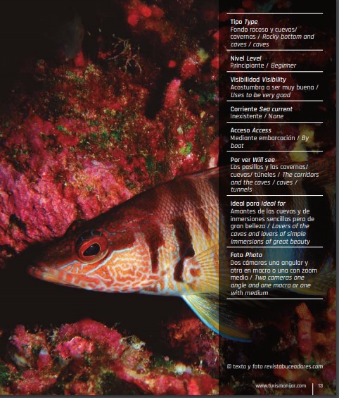
CUEVA DEL FRÍO
Los pasillos rocosos y la pequeña cueva Ideal para Amantes de la fotografía macro e inmersiones sencillas
de gran belleza
Foto : Angular en la cueva y Macro en el resto del buceo
The rocky
corridors and the small cave
I deal for Lovers of macro photography and simple immersions of great beaut
- Tipo : Fondo rocoso
- Nivel: Principiante
- Visibilidad : Acostumbra a ser buena
- Corriente: Inexistente
- Acceso Access: Mediante embarcación
- Level: Beginner
Visibility: Uses to be very good
Sea: current None
By boat: Por ver Will see
Photo: Angular in the cave and macro in the res
Está alejada de la pared del acantilado y es preferible que te lleven si quieres encontrarla.
La boya de fondeo está situada a unos -5 m de profundidad. Descendemos hasta un fondo arenoso y después de nadar un buen rato llegamos a la entrada de una pequeña cueva.
Traspasado su umbral, en la entrada veremos una pequeña chimenea que asciende hacia superficie, pasando de 11 m a 3 m. Atención al hinchado incontrolado del chaleco al ascender, pues el orificio de salida es muy pequeño.
Así también evitaremos deteriorar el entorno de la salida. Tanto la ida como la vuelta se realizan por estrechos pasadizos rocosos. Es conveniente ir provistos de linterna o foco.
It is away from the cliff face and it is better to have someone to take you if you want to find it.
The mooring buoy is located about -5 m deep.
We descend to a sandy bottom and after swimming for a long time we arrive at the entrance of a small cave.
After crossing its threshold, at the entrance we will see a small chimney that ascends to the surface, passing from 11 to 3 m. Particular attention should be paid to the uncontrolled inflation of the vest when ascending, because the exit orifice is very small.
This will also prevent the damage of the surroundings of the exit. Both the entrance and the exit are made by narrow rocky passages.
It is convenient to have
flashlight or torch
EL PECIO DE AGUA AMARGA
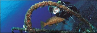
Ideal para Ideal for Amantes biología marina e inmersiones relax
Lovers
marine biology and relax dives
Foto Photo Angular para el pecio y macro
para peces / Angular for the wreck and macro for fish
Tipo Type
Pecio / Shipwreck
Nivel Level
Principiante y cursos de buceo
/ Beginner and diving courses
Visibilidad Visibility
Buena / Good
Corriente Sea current
Inexistente / None
Acceso Access
Mediante embarcación / By
boat
Por ver Will see
La pequeña embarcación, el
resto es posidonia / The small
boat, the rest are posidonia
Sobre un fondo de arena rodeado completamente de Posidonia, yace un pequeño pecio de unos 12 m de eslora. Está en posición de navegación y tiene unos cuatro años de antigüedad. La profundidad a la que yace hundido, a menos 10 m, lo hace accesible a todos los niveles de buceo y nos llamó la atención la gran cantidad de vida que lo ha colonizado.
Serviolas nadando a su alrededor, varios ejemplares
de meros que no huyen, falsos abadejos a tocar, morenas, etc
On a sandy bottom completely surrounded by Posidonia, lies a small wreck about 12 m long. It is in navigation position and is about four years old. The depth to which it lies sunk, -10 m, makes it accessible to all diving levels. The large amount of life that has colonized it caught our attention, amberjacks swimming around him, several specimens of groupers who do not flee from you, goldblotch groupers you can touch, moray eel, etc